HomeIndustryAerospace and DefenceISRO launch: India's own ‘cartographer on space’ Cartosat-2 with 30 nano satellites

    ISRO launch: India’s own ‘cartographer on space’ Cartosat-2 with 30 nano satellites


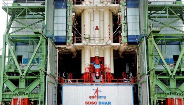
    The overachiever rocket PSLV-38 by ISRO was launched from Satish Dhawan Space Centre in Sriharikota, Andhra Pradesh on June 23, 2017, cargoed with the Cartosat-2 series satellite with along 30 other international co-passenger satellites.

    The 28-hour countdown for the launch began at 5.29 am on the day before.

    With the launch of this third spacecraft in Cartosat-2 series, India widens its bird-view capacity that shall aid the defence sector extensively.

    India’ surgical strike on seven terror launch pads across the Line of Control in 2015 is credited to the resourceful images taken by ISRO’s previous satellite in the Cartosat-2 series, which had a resolution of 0.8 metres, ISRO sources said.

    With a resolution of 0.6 metres, the new satellite can figure more minute objects.

    This is also the 40th flight of PSLV and the 17th flight of PSLV in ‘XL’ configuration (with the use of solid strap-on motors).

    This time the PSLV rocket will be loaded with a 712 kg Cartosat-2 series satellite and additional weight of 30 co-passenger satellites with a total weight of 243 kg into a 505 km polar Sun Synchronous Orbit (SSO).

    Cartosat-2 series satellite is primarily a remote sensing satellite with the objective of providing high-resolution scene-specific spot imagery, similar to its previous editions.

    Nano- satellites from 14 countries, namely Austria, Belgium, Chile, Czech Republic, Finland, France, Germany, Italy, Japan, Latvia, Lithuania, Slovakia, United Kingdom, and the United States of America has given company to the one from India.

    The international nanosatellites are being launched as part of the commercial arrangement between Antrix Corporation Limited, the commercial arm of ISRO and International customers.

    Applications of the images taken from the Cartosat-2 series satellite will come to aid in cartographic applications, urban and rural applications, coastal land use and regulation, utility management like road network monitoring, water distribution, creation of land use maps, change detection to bring out geographical and manmade features and various other Land Information System (LIS) and Geographical Information System (GIS) applications.

    The satellite will also record videos from its orbit that shall come handy for a wide range of activities including military and civil planning.

    ELE Times Bureau
    ELE Times Bureauhttps://www.eletimes.ai/
    ELE Times provides a comprehensive global coverage of Electronics, Technology and the Market. In addition to providing in depth articles, ELE Times attracts the industry’s largest, qualified and highly engaged audiences, who appreciate our timely, relevant content and popular formats. ELE Times helps you build awareness, drive traffic, communicate your offerings to right audience, generate leads and sell your products better.

    LEAVE A REPLY

    Please enter your comment!
    Please enter your name here

    Related News

    Must Read

    Nuvoton Launches Arbel NPCM8mnx System-in-Package (SiP) for AI Servers and Datacenter Infrastructure

    Breakthrough BMC Innovation Powers Secure, Scalable, and Open Compute...

    STMicroelectronics joins FiRa board, strengthening commitment to UWB ecosystem and automotive Digital Key adoption

    STMicroelectronics has announced that Rias Al-Kadi, General Manager of the...

    NEPCON ASIA 2025: Showcasing the Future of Smart Electronics Manufacturing

    NEPCON ASIA 2025, taking place from October 28 to...

    Renesas Expands Sensing Portfolio with 3 Magnet-Free IPS ICs & Web-Based Design Tool

    New Simulation & Optimization Platform Enables Custom Coil Designs...

    IEEE IEDM, 2025 Showcases Latest Technologies in Microelectronics, Themed “100 Years of FETs”

    The IEEE International Electron Devices Meeting (IEDM) is considered...

    OMNIVISION Introduces Next-Generation 8-MP Image Sensor For Exterior Automotive Cameras

    OMNIVISION announced its latest-generation automotive image sensor: the OX08D20, 8-megapixel (MP) CMOS...

    Vishay Intertechnology Expands Inductor Portfolio with 2000+ New SKUs and Increased Capacity

    Vishay Intertechnology, Inc. announced that it has successfully delivered...

    Keysight to Demonstrate AI-enabled 6G and Wireless Technologies at India Mobile Congress 2025

    Keysight Technologies will demonstrate 20 advanced AI-enabled 6G and...

    Ashwini Vaishnaw Approves NaMo Semiconductor Lab at IIT Bhubaneswar

    As part of a big push towards the development...